September 26, 2020


The Loess Hills extend from Missouri up to northern Iowa, following the east side Missouri River. They're made from fine air-blown silt, which I'd suppose is responsible for the fertile agricultural land in the region.
The National Wildlife Refuge includes the bluff and also quite a bit of the flood-plain of the Missouri River, so they've got the wetlands for the migrating birds as well as the creatures that live in the bluffs.
 Loess Bluffs National
Wildlife Refuge
Loess Bluffs National
Wildlife Refuge
The refuge was established on August 23, 1935 as an Executive Order by President Franklin D. Roosevelt as a refuge feeding and breeding ground for migratory birds and other wildlife. The refuge includes 7,440 acres of wetlands, grasslands, and forests along the eastern edge of the Missouri River floodplain.
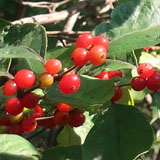
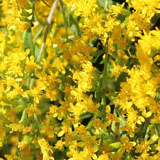
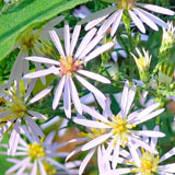
Overlooking the refuge from the east, the loess bluffs habitat is a geological formation of fine silt deposited after the past glacial period. These unique hills stretch from about 30 miles south of St. Joseph, Missouri, to extreme northern Iowa. Some of the last parcels of native plants, remnants of a once vast native prairie, can be found here.
The refuge was named one of America’s top 500 Globally Important Bird Areas by the National Audubon Society in 2001.
--NWR website
 Missouri
The hill, below, is entirely within the refuge. The trail I took climbs up to the ridgeline (which is quite narrow) extends a ways along it, and then comes back down to close the loop. It's classified as strenuous because the "getting up" and "getting down" means lots of stair-steps; otherwise, it's easy enough.

Unfortunately, the virus has kept the visitor center closed; it looks like a nice one.


To do the full trail, you'd need to do a figure-eight.


These trails were established years ago by the CCC. The did a nice job and (just as importantly) the trails have been maintained.

You are rewarded with your 300 foot vertical climb (my guess) by a shelter at the top as well as a nice view of the Missouri River plain to the west.

There are many cresent-shaped lakes that are the remnants of the ancient path of this ever-changing river.


Parts of the path can be kept clean by mowing. It's a pleasant trail.


It's not so clear, but in places, there's quite a steep drop-off on both sides of the trail. Rails on both sides makes sense.


Most of the acreage of the refuge looks like this. I'm sure it's more attractive to migrating birds than the bluffs where I spent most of my time.
